Authorized Reseller · Made in USA · NDAA Compliant

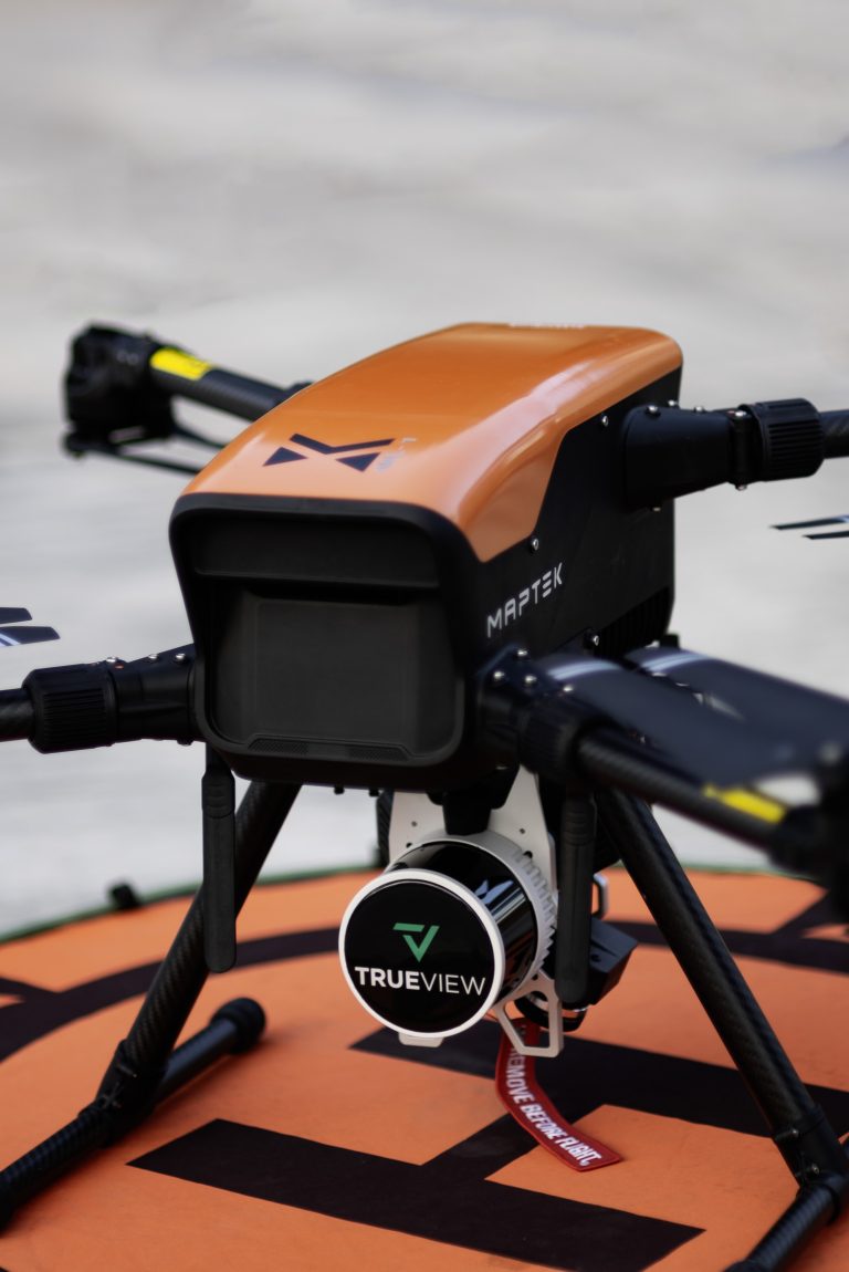
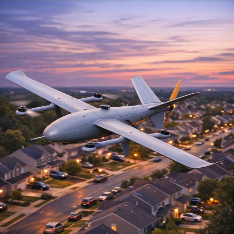
Commercial Drone SystemsMaptek ML1 Multirotor · ELF Fixed-Wing · Public Safety & AEC Ready

Professional UAS platforms for police, fire, government, construction, surveying, and commercial operations across Northern NJ, Southern NJ, NY, PA, and South FL. Airborne in under 2 minutes. NDAA and TAA compliant. No foreign company permission required to fly in controlled airspace, with onboard RTK, BVLOS-ready endurance, and FAA Part 107 mission support.

70 min flight timeNJ · NY · PA · South FLNDAA + TAA compliantMade in Carlisle, PA
Request Drone Information
Tell us about your mission profile and a drone engineer will follow up. We typically reply within 4 business hours.

    Your Name (required)

    Your Email (required)

    Subject

    Your Message

    Your info stays with us. No resale.

    What are Maptek Commercial Drone Systems? Maptek UAS are US-made, NDAA and TAA compliant unmanned aircraft systems built for public safety, construction, surveying, and government missions. The Maptek ML1 multirotor (12 LBS lift, 70 min flight, onboard RTK) and ELF fixed-wing (50 km range, 3.5 hr endurance, BVLOS-ready) are designed and manufactured by Aerostar Dynamics in Carlisle, Pennsylvania. On-Site Technology is an authorized Maptek reseller serving Northern NJ, Southern NJ, NY, PA, and South FL with procurement, FAA Part 107 pilot training guidance, and ongoing operational support.

    70 min

    Max Flight Time

    12 LBS

    Lift Capacity

    NDAA

    Compliant Platform

    USA

    Designed & Built

    Maptek ML1 multirotor drone idling
    Multirotor Platform

    Maptek ML1

    A medium-lift, NDAA-compliant quadrotor built for demanding professional environments. With up to 70 minutes of flight time, onboard RTK, fleet management, and interchangeable payloads, the ML1 is airborne in under 2 minutes and ready for virtually any mission. No foreign company permission required to fly in controlled airspace.

    Flight Time

    Up to 70 min

    Lift Capacity

    12 LBS (23 custom)

    Wind Resistance

    35 mph / 30 kts

    IP Rating (GCS)

    IP54 · IP65 · IP67

    ✓ Onboard RTK (dual optional) ✓ 900MHz telemetry ✓ Fleet management ✓ Hot-swap batteries ✓ OFDM transmission ✓ Automated mission planning

    Request Pricing

    Fixed-Wing Platform

    Maptek ELF

    ELF (Extreme Longrange Fixedwing) sets a new standard in endurance UAV performance. With a 3.5-hour flight time, 50 km range, BVLOS capability, and AI-powered AIRLink flight controller, the ELF excels at large-area surveys, environmental monitoring, perimeter defense, tactical reconnaissance, and long-line infrastructure inspection.

    Flight Time

    Up to 3.5 hours

    Range

    50 kilometers

    Payload Capacity

    4.2 lbs / 2 kg

    Structure

    Carbon Fiber

    ✓ BVLOS capable & ready ✓ AIRLink AI autopilot & LTE ✓ LiDAR & photogrammetry-ready ✓ Real-time telemetry streaming ✓ 2500mm wingspan ✓ NDAA compliant

    Request Pricing

    Maptek ELF Longrange Fixedwing drone

    Drone Solutions for Every Mission

    From active shooter response to ALTA surveys and insurance inspections, the Maptek ML1 and ELF adapt to virtually any tasking, environment, or agency requirement.

    🚔

    Police & Public Safety

    Active shooter response, barricade situations, scene reconstruction, digital twin capture, arson investigation, NOTAM filing, SGI operations, and crowd control with the OVC OverCast payload. RTK centimeter-level precision for evidence capture.

    🔥

    Fire Departments

    Thermal imaging through smoke, mist, and fog with the 1266×1010 30Hz Workswell camera. Live-streaming to command via Airwise. Initial and ongoing fire size-ups, hotspot detection, resource management, and arson documentation.

    🏗️

    Construction

    LiDAR and RGB photogrammetry for AEC workflows. Dual RTK for centimeter-level precision, pointcloud generation, terrain-following, and automated corridor surveys. Data-compatible with all major AEC and assembly software.

    📐

    Surveying & Mapping

    ALTA surveys, topographic capture, corridor mapping, and BVLOS operations with the ELF. Onboard RTK, 900MHz telemetry, and hardened GCS options for every environment from basic mapping to oil-rig conditions.

    🏢

    Insurance & Inspection

    High-resolution RGB and thermal imaging for property damage assessment, roof inspections, infrastructure surveys, and claims documentation. Repeatable automated flight plans ensure consistent, admissible evidence capture.

    🌳

    Parks & Recreation / Municipal

    NDVI vegetation mapping, trail and facility surveys, environmental monitoring, perimeter security, and event overwatch. Quiet and efficient for sensitive public spaces across Northern NJ, Southern NJ, NY, PA, and South FL.

    See the ML1 in Action

    Watch how the Maptek ML1 performs across public safety, construction, and surveying environments.

    Compatible Payload Partners

    Sensor Ecosystems for Any Mission

    SONY
    RIEGL
    FLIR
    GeoCue
    Workswell

    Choose Your Bundle

    Every bundle includes the ML1 airframe. Choose the ground control station that best fits your operations and compliance requirements.

    Entry Level

    Basic Bundle

    Contact For Pricing

    US-made · Non-NDAA


    ✓ ML1 Airframe + Herelink GCS
    ✓ Survey, mapping & topographic capture
    ✓ Automated flight & camera control
    ✓ Flight services included
    × Not dust/waterproof
    × Not NDAA-compliant

    Get a Quote

    ★ Most Popular

    Recommended

    Standard Bundle

    Contact For Pricing

    NDAA & TAA Compliant


    ✓ ML1 Airframe + UVX Controller (IP65)
    ✓ NDAA & TAA compliant
    ✓ Customizable action buttons
    ✓ Smoke/gas release triggers
    ✓ Water sampler capable
    ✓ Rugged field-ready GCS

    Get a Quote

    Enterprise / Public Safety

    Professional Bundle

    Contact For Pricing

    NDAA & Blue Compliant


    ✓ ML1 Airframe + SROC7 Tablet (IP67)
    ✓ Tested underwater for one week
    ✓ NDAA & Blue-compliant
    ✓ Harshest environments rated
    ✓ High-hazard / high-contaminant
    ✓ Enterprise public safety ready

    Get a Quote

    How the ML1 Compares

    The Maptek ML1 outperforms competing platforms across every critical mission metric, at a lower NDAA-compliant price point.

    SpecificationMaptek ML1Inspired IF800FreeFly AstroDJI Matrice 400
    Max Flight Time70 min55 min39 min59 min
    Max Lift Capacity12 LBS6.6 LBS6.6 LBS12 LBS
    Wind Resistance35 mph / 30 kts22 mph / 19 kts22 mph / 19 kts27 mph / 14 kts
    Onboard Fleet Mgmt✓ Yes× No× No× No
    Onboard RTK✓ Yes (Dual Opt.)Extra CostExtra Cost× No
    NDAA Compliant✓ Yes✓ Yes× No× No
    Made in USA✓ Yes✓ Yes× No× No (China)
    No Flight Restrictions✓ Yes× No× No× No
    Ready to Scope a Drone Program?

    Tell Us About Your Mission

    Share your agency, mission profile, and timeline. A drone engineer will follow up with a scoped quote for the platform and bundle that fits. We typically respond within 4 business hours.

      Your Name (required)

      Your Email (required)

      Subject

      Your Message

      Your info stays with us. No resale.

      Frequently Asked Questions

      Is the Maptek ML1 NDAA-compliant?

      Yes. The Maptek ML1 Standard and Professional Bundles are fully NDAA (National Defense Authorization Act) and TAA compliant, making them eligible for federal, state, and local government procurement. The Basic Bundle uses US-made components but does not carry formal NDAA certification. All platforms are designed and manufactured by Aerostar Dynamics in Carlisle, Pennsylvania.

      Can the ML1 fly in controlled airspace without restrictions?

      Yes, and this is a major differentiator. Unlike many competing platforms (particularly DJI), Maptek does not restrict or geofence your flight based on location. Pilots define their own geofencing when and if required. The system also supports SGI (Special Government Interest) and NOTAM filing, making it purpose-built for law enforcement and public safety operations in complex urban airspace. No need to ask a foreign company for permission to fly.

      What payloads are compatible with the ML1?

      The ML1 supports interchangeable payloads from Sony (60MP RGB), Riegl (LiDAR), FLIR (thermal), GeoCue, and Workswell (highest-resolution commercial thermal at 1266×1010 30Hz). For law enforcement, the OVC OverCast system enables crowd control via remotely-triggered 40mm smoke, OC, or CS canisters. Most payload adaptations work straight out of the box; specialized configurations are handled at the Maptek facility in Carlisle, PA.

      What is the difference between the Maptek ML1 and ELF?

      The ML1 is a multirotor optimized for VTOL, precision hovering, and payload deployment with up to 70 minutes of flight time and 12 LBS of lift. It excels at close-range, high-precision missions. The ELF (Extreme Longrange Fixedwing) is designed for endurance, with up to 3.5 hours of flight and a 50 km range. The ELF is ideal for BVLOS large-area surveys, perimeter monitoring, and infrastructure inspection where long loiter time matters more than precision hovering.

      Does On-Site Technology provide training and support?

      Yes. As an authorized Maptek reseller, On-Site Technology provides procurement assistance, FAA Part 107 pilot training guidance, and ongoing operational support for all Maptek UAS platforms across Northern NJ, Southern NJ, NY, PA, and South FL. Call (973) 777-7227 or use the contact form on this page to discuss your department or company requirements.

      What government and commercial entities use Maptek drones?

      Maptek UAS are in use by police and sheriff departments, fire departments, municipal governments, AEC and construction firms, land surveyors, environmental agencies, insurance companies, parks and recreation departments, and private commercial operators. The platform NDAA compliance and unrestricted airspace access make it a leading choice for any government agency subject to federal procurement requirements.

      Do you serve drone customers outside New Jersey?

      Yes. On-Site Technology is the authorized Maptek reseller for Northern NJ, Southern NJ, New York, Pennsylvania, and South Florida. Because drone procurement involves hardware delivery, pilot training, and on-site mission planning, we focus our coverage on this regional footprint. Customers outside the region should contact Maptek directly for a local reseller referral.

      Ready to Deploy Maptek Drone Systems?

      On-Site Technology is your authorized Maptek reseller for Northern NJ, Southern NJ, NY, PA, and South FL. Whether you are a police department, fire company, construction firm, or surveying operation, we are ready to discuss your mission requirements.